
 This is just the beginning! Our collection holds over 300 years of history, including rare newspapers, obituaries, marriage records, birth records, and so much more—most of which you won’t find anywhere else!
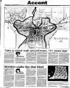
Visual walk around Elyria 1857 map highlights town layout
A detailed 1857 Atlas of Elyria Lorain County Ohio reveals Broad Street clustering from Cedar to West Avenue and the East and West River roads then, with Plank Road northward and the Cleveland and Toledo Railroad as a single track. The map shows four river bridges, a small depot station, early cemeteries and churches, and the Beebe and American houses. It notes Heman Ely's early settlement, a fairgrounds site, Union School, and the jail near St Andrews, with many streets unnamed or later renamed, plus potential U.S. Armory at Eighth Street. The piece invites readers to examine the fragile, largely horse-drawn town with woodlands and blank areas, and mentions street-name origins and enduring natural features.
MENTIONED IN THIS ARTICLE
Broad Street
Cedar
West Avenue
Ely Square
Second Street
South Street
Huron
East
West River
Cleveland
Tion
Lorain
Cleveland and Toledo Railroad
Depot Street
Lodi
Lake Avenue
Washington Avenue
East River
Ridge Street
Park Place
Fairgrounds
Heman Ely
Third Street
Union School
Elyria High School
Broad and
Court Streets
Beebe House
Broad
Lorain County
Mid
Dle
Third Streets
St. Andrews Episcopal Church
Second
Second and
Court
U.S. Armory
Eighth Street
Armory
A.D. Howe
Howe
Elyria
Rockwood
Pond
Massey
Byington
Boynton
Bishop
Belden
Gates
Starr