
 This is just the beginning! Our collection holds over 300 years of history, including rare newspapers, obituaries, marriage records, birth records, and so much more—most of which you won’t find anywhere else!
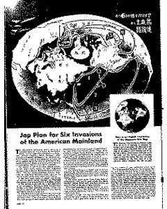
Jap Plan for Six Invasions of the American Mainland
A 1943 picture magazine map, found by Seventh Air Force engineers, outlines six invasion routes to the United States. Routes include attacks via Aleutians to Alaska, a Pacific sweep to California via Hawaii, a New Zealand coastal thrust, a Nazi drive through Iceland to Chicago, Britain's fall with a transatlantic strike to New York, and a South Atlantic path to New Orleans aided by internal fifth column networks. The map notes internal collaborators but omits a Panama Canal capture plan.
MENTIONED IN THIS ARTICLE
United States
Americcan
Seventh Air Force
Makin
America
Germany
Italy
Axis
Vichy France
Japan
North Pacific
Aleutians
Alaska
Alaskan
New Guinea
Pacific
California
Pearl Harbor
Hawaii
New Zealand
South Pacific
South America
Panama Canal
Australia
Central
U.S
North Atlantic
Norway
Iceland
Greenland
Labrador
Canada
U. S
Chicago
Britain
Atlantic
New York
British Isles
France
Spain
North Africa
South Atlantic
Brazil
Gulf of Mexico
New Orleans