Notice of Mining License Application in British Columbia
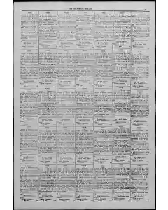
Notice is given that thirty days after date I intend to apply to the Chief Commissioner of Lands and Works for a coal and petroleum prospecting license on lands in Southeast Shootenay District British Columbia Block 4603. The claim begins at a post near the D. J. Witzgerald claim and Nellie Sylvester claim north-west corner, runs east 80 chains south 80 chains west 80 chains north 80 chains to commence point, containing 10 acres more or less. Located this 0th day of October Wu Roy Allen Agent for Nellie Sylvester Locator Witness: Haptiste X. Lamertoux.
MENTIONED IN THIS ARTICLE
Shootenay
British Columbia
D. J. Witzgerald
Nellie Sylvester
Kootenay
Chas. Fiske
H. Mason Raburglaim
Cbiel Colmessioner
Saints and
Woths
Fenny
Unlock
Elain Jolied
Mason Roburg
Wm. A. Kerr
Jens
Ton
D. J. Fitzgerald
Chief Commissioner of Lands
Anl
H. P. Bennett
Jno
M. T. Raburg
Tno
MacGinnis
P. Bennett
Nsootenay
Flosse Macginns
Lands
Ani
Chas
Dirnwell
Bennett
D. J. Puggerall
Chief Commissioner of Lands Amt
Chas. Gruwell
Jno. MacGinnis
Ootenay
Baptiste Lamerioux
Kootfenay
Tlock
Petr
H. J. Cummings
Tne MacGinnis
Eloise Macinniss
Bloise MacGinnis
Stoner
Hloise MacGinnis
Arthur Perham
N. E
S.W. Corner
Notice of land claim in Southeast Koo District
Government notice records a land claim located about one mile south of Charles Fiske’s claim on the east boundary of Block 4593. The parcel totals 110 acres and is described by a square boundary of 80 chains on each side. Dated October 40, 1911, Rey Allen as agent for H. Mason Raburg and locator Baptiste X Lamerionx.
MENTIONED IN THIS ARTICLE
Rey Allen
H. Mason Raburg
Baptiste X Lamerionx
Notice of Lands Claim Near D. J. Fitzgerald’s Claim
Thirty days after date one of intent to apply to the ton Chief Commision roleum on lands described as at the northeast corner of D. J. Fitzgerald’s claim on the east boundary of Block 4593. A square 80 chain by 80 chain tract is located, forming a 640 acre area. Located November 1, 1911. Baptiste X Lamerloux his mark.
Notice of Location Claim in British Columbia Block 4593
Notice states intent to locate a 610 acre land claim in Block 4593 near H. P. Bennett and I. J. Fitzgerald, starting at a post about 1 mile west of the northeast corner, with bounds described as 40 chains per side and total area 610 acres. Located November 1 by I. J. Witzgerald as locator and Baptiste Lanertouy as witness.
Notice of Lands and Boundary Claim by Jno MacGinnis
Locating a 640 acre parcel near the south-west corner of Jno MacGinnis claim. The notice, dated November 1, names Baptiste X Lamereaux as marker and requests approval from the Chief Commissioner of Lands and Works within thirty days.
Property boundary claim description near Block 4593
The text describes a land claim dating about thirty days after a date in 1593, joining Charles Fiske on the east boundary of Block 4593 and M. T. Raburg on the southeast corner. It details boundaries with west zero chains, north 40 chains, east 80 chains, and south to the starting point, totaling 610 acres more or less, with Baptiste X Lamerioux as locator.
Lands and Works Block Boundary Description in Southeast Koo
A government notice outlines a land parcel in Southeast Koo District. It details a 610 acre tract bounded by the east boundary of Block 0S and the southwest corner of Charles Fiske’s claim, with measurements North 10 chains East 80 chains South 10 chains West 6 chains. Baptiste X Lamerieux signs as locator witness.
Land claim description near Block 4993 and Bennett corner
The document details a land claim situated about thirty days after dates near one mile south of TNO. MacGin nis claim on the north east corner of the east boundary of Block 4993 and as the north east corner post of N P Bennett claim. It describes a boundary: south 80 chains, west 80 chains, and ent, totaling about 640 acres more or less. Witnesses: Hl P Bennett, locator, Wilne on Baptiste X Lametiouz.
Nellie Sylvester and Flosse Macginnis Claim Boundaries
Legal notice fragment describes a district claim in the Southeast Nsoo district with a boundary description near Nellie Sylvester and Flosse Macginnis claims. It names Eloise Macginnis as locator and Baptiste Lamertoux as witness, noting measurements and bearings approximate to an acre parcel.
Property Claim Boundaries Described in Oct 30 Notice
A dated October 30 notice defines a 10 acre parcel beginning at the Nellie Sylvester claim northwest on east boundary of Block 4693 and northeast corner of Jno Macginnis, with boundary lines set 80 chains in four directions. Witnesses recorded.
Boundary Claim Described in British Columbia Lands Record
A land description notes a claim near Chas dirnwell's post in Block 41593 in British Columbia. It outlines a 610 acre tract defined by a series of 80 chain and 8 chain bounds ending at the point of commencement. Witnesses listed include H. P. Bennett and Nismark.
Boundary description for Nellie Sylvester claim in Tenay BC
The document describes Puggerall's claim on east raindars of Block 1h at the northwest corner post of Nellie Sylvester claim. It specifies bounds: east 80 chains, south 50 chains, west 80 chains, north 0 to the start, totaling 40 Located this 80th day of October, Wi, Withesst.
Notice of Claim Location in Southeast Koou District
Notice to claimants that on the 00th day of October Jno MacGinnis locator declares a location near where the Southeast Koou district meets Chas Gruwell and the east boundary of Jno MacGinnis corner post.
Claim Boundaries of MacGinnis Lode Located Oct 4 191
Boundaries described as starting at the southeast corner post of the MacGinnis claim. Chain measurements run west 80, north 80, east 80, south 80 to the point of commencement. The document notes filing thirty days after date with the Mon Chief Commissioner and references witness Nh Wi-Bt.
Baptiste Lamerious Claim Boundaries Placed in Record
In the District of Southeast near one mile south of Block 1638 on the east boundary of Block 4694 the south east corner post marks the Baptiste Lamerious claim. The survey runs west 80 chains south 80 chains and north 80 chains to the starting point totaling 610 acres more or less. Located October 28, 111. Baptiste X Lamerious his mark Locator Roy Allen 45-51.
Boundary description for Perham claim in British Columbia
Located October 20 by Arthur Perham, locator Baptiste Lamperioux. Describes claim bounds in Block 4593 AML, southeast corner near Chas Gru well, extending 640 acres more or less from a start point and returning by 80 chain east and west legs and north and south lines.
Boundary description of 610 acre WL claim WL 45 1t
A legal land description begins at a post near claim 10078 on the northwest corner of the east boundary of Block 4593 and uses the southwest corner post of the Arthur Perham claim. The survey proceeds 80 chains to the south, forming a 610 acre parcel with a specified commencement point and directions.
Prospectors License Related to British Columbia Coal Claim
A notice describes a license to prospect for coal and petroleum on lands in Tenay British Columbia near the Wm. A Kerr and Chas Gruwell claims. It outlines boundaries with a series of 80 chain segments forming a closed rectangle and names Locator and Witness.
Kerr claim 40 acre tract description at Hex
Legal description details a 40 acre land tract located near the southwest corner of H J Cummings east boundary and Wm A Kerr claim. It specifies a chain-based boundary. the locator is Wm A Kerr and the document is dated October 28.
Kerrs claim on south west corner post boundary block 1503
Property description notes A Kerr claiming the south west corner post on the east boundary of Block 1503 and the north west corner post of Charles Gruwell’s claim. It proceeds 80 chains east then 80 chains south then 80 chains west and terming north to origin, totaling 610 acres. Witness locator not shown.
Boundary claim note for Eloise MacGinniss parcel extends to east boundary
A brief boundary description notes Roy Ren as agent for Eloise MacGinniss and marks the claim as near the corner post along the east boundary of Eloise MacGinniss acres. The description indicates the parcel limit is a matter of record within the adjoining claim.
Land claim description for Jno MacGinnis and Fitzgerald
The document describes a land claim joined by D. J. Fitzgerald. It begins at a post one mile north on the east boundary of Block 459 and the southwest corner of Jno. MacGinnis. It runs north 80 chains, east 40 chains, south 80 chains, and west 40 chains to the starting point, totaling 640 acres.
Boundary description of Bloise MacGinnis claim near Kerr
Provides a land patent note locating Bloise MacGinnis claim at the east boundary near William A Kerr, describing a rectangle of 640 acres with a corner post and boundary measurements. Dated October 30. Locator: Bloise MacGinnis.
Land claim notice for Eloise MacGinnis Locater
A description outlines a land claim on the south east corner of block 4593 bounded by a series of lines totaling 646 acres. Eloise MacGinnis is listed as the claimant with the locator designation.
Boundary description of Fassett and Fitzgerald claims
South east corner of H P Bennett's claim on east boundary of corner post of D J Fitzgerald claim runs north 80 chains east 80 chains south 80 chains and west 80 chains to the starting point Located this 30th day of October 1011 Locater D J Fitzgerald
Boundaries for Claim No 1333 Described at Tenay BC
Located Oct 23 by Baptiste X Lameriouz, post planted near re staking of claim 1333. Boundary runs west 60 chains then north 80 chains to form 640 acres. Mentions M. T. Raburg claim and southwest to northeast corner reference.
Land Claim Boundaries Describe M T Raburg and Kerr Parcels
Southeast corner of M T Raburg claim on east boundary of Block 4593 forms the southwest corner of Wm A Kerr claim. Boundaries run east 80 chains, north 80 chains, west 80 chains, and south to the Kerr locator Baptiste X Lameriour.
Lands commissioner role and claim outline near Raburg locator
Fragmentary notice mentions the Lands commissioner in relation to a land claim near the northwest corner of claim No. 10078 linked to H. Mason Raburg. The text references a locator and witness mark but lacks full details.
Re-staking of Arthur Perham Claim Post Described
Boundary description notes a southeast corner post in Block 4593 and the southeast corner of Arthur Perham claim. The parcel runs 80 chains west, 80 chains north, 80 chains east, and 86 chains south to the point of commencement, locating the claim by Arthur Perham.
Notice of coal prospecting license for H J Cummings
Public notice announces a license to prospect for coal granted to H J Cummings, identified as locator, outlining the authorized holder and purpose of the permit.
Thirty Days After Date 1 Notice
A terse legal notice states an intent to mark within thirty days after date 1. It appears as a procedural filing referencing a deadline and action to be taken by a named party.
Land Patent Claim by Belden for Fiske Block 4593
On October 11, A W Belden as agent for Chas Fiske locates a 640 acre parcel one mile east of the west boundary line of Block 4593 at the N E corner, describing a 640 acre tract with 40 and 80 chain legs and a return to the starting point.
Fiske Claim Metes Out Quarter-Section Boundary
Description places the claim one mile east of the 25 mile mark Block 4593 and the southwest corner of Charles Fiske's claim. It runs north 80 chains east AO chains south 80 chains and west 40 chains. Located October 17 by locator Charles Fiske with witness Blemark.
Also Mentioned on This Page
Roy Allen
Haptiste
Lamertoux
Mark
Eloise MacGinnis
Baptiste X. Lamerioux
Rov Adle
Win
A. Were
Baptiste X
Lanerioux
Baptiste X Lamerloux
I. J. Fitzgerald
I. J. Witzgerald
Baptiste X Lanertouy
Locator
Baptiste X Lamerfoux
Baptiste X Lamerioux
Chas, Fiske, Locator
Baptiste X Lamerieux
Wilne
Lametiouz Bis
Witness
Leeaster
Lamerioux Nismark
Withesst
AA Baptiste
Lamerioux
Duo
Baptiste
Baptiste X Lamperioux
Gruwell
Lamerioux ‘bin
A. Kerr
Roy Ren
Eloise MacGinniss
Locater
Baptiste X Lamerious
Lameriouz
Lameriour
Tock
Cormer
HJ. Cummings
Mason Raburg
A. W. Belden
Baptiste X Lamerioux Blemark

 This is just the beginning! Our collection holds over 300 years of history, including rare newspapers, obituaries, marriage records, birth records, and so much more—most of which you won’t find anywhere else!